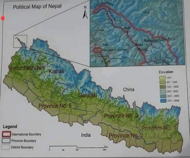
Nepal on Monday released a new map protesting Pithoragarh's Garbadhar-Lipulekh route as an encroachment. In this, Nepal has claimed to set a new international boundary, describing the Pithoragarh script and Kalapani as its territory. Nepal has changed only the 805 km border with Uttarakhand. Along with Ladakh, Himachal Pradesh, Uttar Pradesh, Bihar, West Bengal, and Sikkim, the border with China has been retained.
The new political map was presented on Sunday in the Council of Ministers of Nepal. After a full day of brainstorming and consultations with foreign affairs experts, the Council of Ministers unanimously stamped the new map on Monday. In this, along with the script, Kalapani decided both the areas of strategic importance by fixing the international border. In the map note, he has also mentioned the encroachment of India in both the areas, describing them as his own. Along with this, Nepal has also claimed its Kuti, Nabi, and Gunji of Pithoragarh. The Council of Ministers of Nepal confirmed the new map in the meeting on Monday and said that it will also be included in the syllabus.
Stress started in 2019
India released the map on 2 November 2019. It also included Limpiyadhura, Lipulekh, and Kalapani. Nepal objected to this and called it contrary to the actual map. Although the dispute calmed down after talks between the two countries, Nepal began to renew it after the Garbadhar-Lipulekh road to the China border in the first week of May.
This is the black water dispute
Kalapani is an area of about 35 square kilometers and is a part of the Pithoragarh district. On the other hand, the Nepal government claims that this area falls in its Darchula district. Since the 1962 Indo-China war, the area has been occupied by Indian ITBP personnel.
There was a diplomatic approach to resolve the matter between the two countries. Soon after the Mahakali Treaty for the joint development of the Kalapani area in 1996, the Communist Party of Nepal (CPN-UML) started claiming Kalapani.
Kalapani is strategically important
Kalapani area on the triangular border of India-China-Nepal is strategically important. The Government of Nepal claims that according to the Sugauli Treaty signed between it and the then East India Company in 1816, Kalapani is its territory. However, Article 5 of this treaty states that Nepal will not claim its territory west of the river Kali (now Mahakali). In 1860, a survey of the land was done in this area for the first time. In 1929, Kalapani has declared a part of India and was also confirmed by Nepal.
Map before the Sugauli Treaty
Yashoda Srivastava, who knows India-Nepal relations, says that the new map Nepal released on Monday dates back to the Sugauli Treaty of 1816. At the same time, former Foreign Minister of Nepal Upendra Yadav says that the solution to any differences with India is possible only through dialogue. The border dispute between the two countries is not new. The government should hold high-level talks with India with documents and maps. Nothing will happen with unilateral initiatives.
Resolve the bilateral issues
BJP MP from Nainital Ajay Bhatt said that India has never interfered in anyone's territory. Our policy was not expansionary. Nepal is a friendly nation. Some misunderstandings that have come out in recent times are being tried to resolve them through bilateral talks. Whenever we built it on our own land.
India-Nepal border dispute: Nepal declares Lipulekh and Kalapani as its own in the new map
![India-Nepal border dispute: Nepal declares Lipulekh and Kalapani as its own in the new map]() Reviewed by Raj Tech Info
on
May 18, 2020
Rating:
Reviewed by Raj Tech Info
on
May 18, 2020
Rating:
No comments: